Road Trip from Winnipeg to Calgary: Scenery and Fuel Stops Along the Way
1. Departure from Winnipeg: The Beginning of the Prairie Voyage
The morning in Winnipeg began with a golden hue stretching across the Red River. Early June carried a crispness in the air, and the promise of summer shimmered in the early light. The car was packed the evening before—snacks, maps, water, camera gear, and a playlist tailored for the long, straight stretches of the Canadian Prairies.
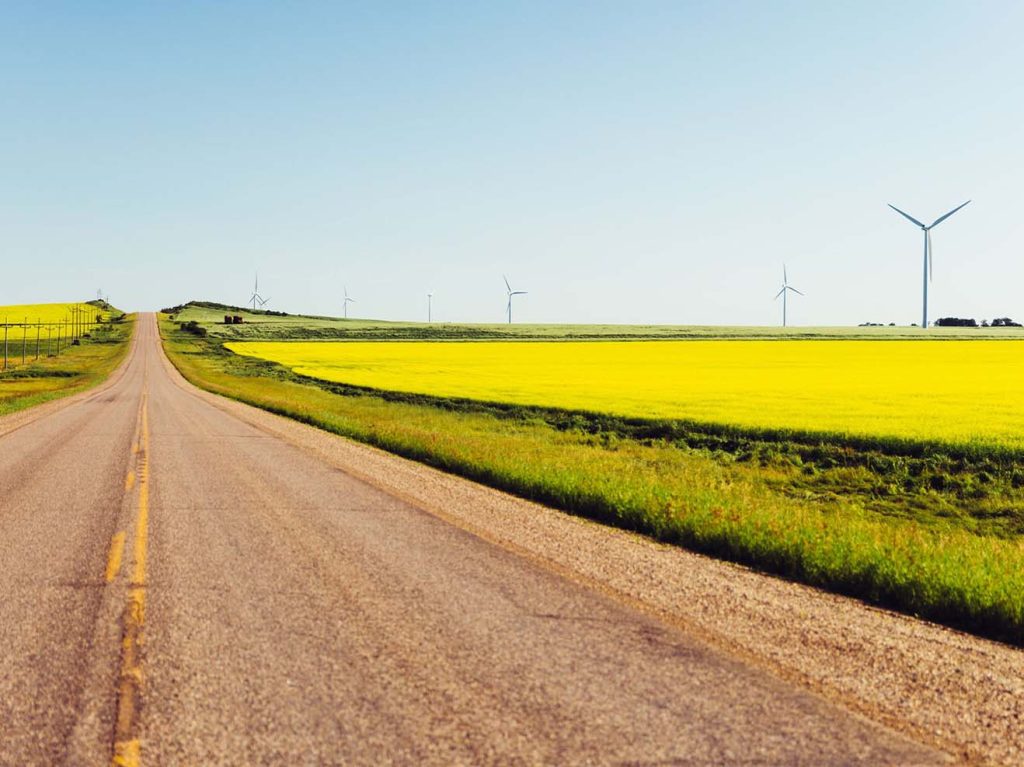
Leaving Winnipeg via the Trans-Canada Highway (Highway 1), there was a quiet thrill in knowing the road ahead would run straight for hundreds of kilometers, flanked by fields, small towns, grain elevators, and gradually rising landforms. As the city skyline faded in the rearview mirror, open space took over. It wasn’t long before fields of canola and wheat began to dominate both sides of the highway, already greening up in June.
Fueling up in Winnipeg before departure is wise, especially near the western edge of the city. The Petro-Canada off Portage Avenue offers a well-maintained station with restrooms, coffee, and a chance to double-check tire pressure before a long drive.
2. Manitoba’s Endless Plains: Portage la Prairie to Brandon
Portage la Prairie appeared roughly an hour west of Winnipeg. This small town, settled beside the Assiniboine River, makes a pleasant early stop. Though not necessary for fuel at this point, the Tim Hortons near the highway served a reliable mid-morning coffee. The fields here, already being tended by farmers on massive tractors, stretched into the horizon in all directions.
Beyond Portage, the land seemed even flatter, more expansive. Silos stood like solitary statues amid a sea of green and gold. It was along this stretch that the vastness of the prairie became both meditative and disorienting. On particularly cloudless days, the sky and the land nearly fused into one.
Brandon, Manitoba’s second-largest city, appeared as a welcome urban break after about two hours of highway driving. Here, it made sense to refuel. The Co-op Gas Bar just off 18th Street had competitive prices, and the adjacent Sobeys made it easy to grab a fresh sandwich and fruit. While in Brandon, it was tempting to take a slight detour into the downtown district, where murals and a few preserved historical buildings stood as reminders of the town’s long-standing role as a regional hub.
3. The Quiet Approach to the Saskatchewan Border
Past Brandon, the prairie began to change subtly. Elevation increased slightly, though the terrain remained characteristically open. Small communities like Alexander and Virden passed in brief flashes—gas stations, farm supply stores, grain elevators.
Virden offered the last sizable stop before crossing into Saskatchewan. The Shell station on the south side of the Trans-Canada was busy with long-haul truckers and local traffic. It was clean, quick, and had a small attached convenience store with surprisingly good local jerky.
Just before the provincial border, the town of Elkhorn appeared. With a population under 1,000, it still maintained a quaint museum showcasing antique vehicles and prairie artifacts. Though it didn’t draw crowds, the village had an oddly calming presence.
The actual crossing into Saskatchewan is unmarked by any fanfare—just a modest sign. The time zone change was more noticeable than the border itself, gaining an hour almost suddenly.
4. Entering Saskatchewan: Broad Skies and Changing Light
The light shifted after entering Saskatchewan. The sky seemed even broader. There was a strange optical trick of the land—no matter how far one traveled, the horizon remained stubbornly distant.
The first major town in Saskatchewan, Moosomin, appeared just over the border. Here, the Esso and Tim Hortons combo on Broadway Avenue made for a good afternoon coffee stop. The Trans-Canada Highway cut cleanly through the town, and local shops stood just a few blocks south. The grain elevator in Moosomin was still active, its chutes echoing with the sound of grain transfers.
From Moosomin to Indian Head, the landscape began to undulate slightly. Gentle hills appeared, and windbreaks of trees lined fields. The region carried an elegant sort of repetition—fence lines, cattle, barns, fields, then again.
5. Regina: A Vital Midway Stop
Reaching Regina felt like arriving at an island in the prairie. The skyline—a modest cluster of buildings—rose gently from the flatness. Approaching from the east, one passed the town of White City, which seemed to have grown rapidly in recent years with new suburban homes and chain stores.
In Regina, the choice of gas stations was abundant. The Husky near Victoria Avenue offered full services, including a car wash and a well-stocked shop. Parking near Wascana Park, just off Albert Street, provided a quiet space to stretch the legs. The park, which encircles a man-made lake, offered shaded paths, geese waddling across lawns, and a strong scent of freshly cut grass.
Lunch came from a local bakery near the Cathedral District, where thick rye sandwiches and rich butter tarts made the stop feel more indulgent than it should have. Regina served as a proper midpoint, not just geographically but mentally—half the journey done, half yet to explore.
6. Out of Regina: Grain Fields and Rail Shadows
West of Regina, the land again opened up. The tracks of the Canadian Pacific Railway ran parallel to the highway in many places. Trains passed at intervals, impossibly long, some over 100 cars.
Communities like Pense and Belle Plaine stood as brief interruptions. Belle Plaine had a curious roadside sculpture park—homemade statues standing proudly among farm machinery.
Approaching Moose Jaw, the road gently curved and dropped into a wide valley. This small city, tucked into hills and coulees, offered another chance to refuel and rest. The Co-op station on Main Street was busy but efficient. Moose Jaw’s historic downtown was worth a 30-minute detour, if only to walk the old sidewalks and peer into shops that hadn’t changed in decades.
7. Swift Current and the South Saskatchewan River Valley
Swift Current arrived after another long prairie stretch. The road between Moose Jaw and Swift Current was among the straightest in the country—kilometers upon kilometers of uninterrupted highway.
Swift Current sits near the South Saskatchewan River, and while small, the town bustled with local commerce. Here, another fuel stop was prudent. The Petro-Canada on Central Avenue had excellent facilities, and across the street, a local diner served the kind of roast beef sandwich that only small-town Saskatchewan seemed to do well.
This section of the highway felt more remote. Fewer cars, longer stretches without visible farmhouses, and a constant wind rolling across open fields.
8. Toward the Alberta Border: Grasslands and Sky Domes
Leaving Swift Current, the sun began its slow descent. Shadows grew longer. The horizon deepened in color.
Maple Creek marked the last major Saskatchewan town before Alberta. Tucked against the Cypress Hills, it stood apart from the otherwise flat surroundings. The Husky station at the edge of town had fuel, snacks, and a regional map worth picking up.
To the south, the Cypress Hills rose unexpectedly, like a green island floating on dry grasslands. Though not on the direct route to Calgary, the detour toward Fort Walsh and the Cypress Hills Interprovincial Park remained tempting. The terrain offered forested ridges, wildflowers, and—depending on the time of day—elk or deer grazing in the distance.
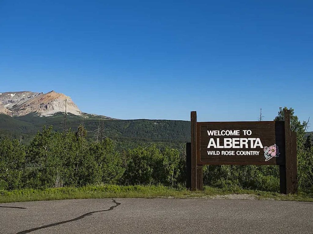
9. Alberta: A Subtle Shift in Terrain and Attitude
Crossing into Alberta, the landscape began to roll more noticeably. Hills emerged, and the soil turned redder. The wind, always present on the prairie, seemed to shift direction more frequently here.
Medicine Hat appeared in the early evening light. Known for its historical gas lamps and brickwork buildings, the city had a quiet, lived-in charm. The Esso just off the Trans-Canada near Dunmore Road provided fuel and clean restrooms, along with a convenience store selling locally produced honey and small-batch chocolate.
West of Medicine Hat, the road dipped in and out of shallow valleys. The prairies here were more dramatic, less uniform. Fence posts leaned with age, and cattle grazed in shadows of hills.
10. Brooks and Bassano: The Bow River Corridor
Brooks, roughly halfway between Medicine Hat and Calgary, marked another key fuel and rest stop. The Co-op station near the city center had efficient service and a surprisingly good hot food counter. The town itself sits along the Bow River, and a short detour south leads to Kinbrook Island Provincial Park—a quiet place with views of waterbirds and reeds.
Bassano, smaller and quieter, had an old-school gas station with a single pump and a tin roof. The town’s name came from the Italian engineer responsible for the region’s irrigation systems, and the community retained a European echo in its layout and architecture.
11. Approaching Calgary: Farmland Yielding to City Lights
As Calgary drew near, the road began to climb imperceptibly. The Rocky Mountains became faintly visible in the distance, especially at dusk, where their jagged outlines caught the last of the daylight.
Communities like Strathmore and Chestermere came quickly. Both towns had fully equipped gas stations and growing residential neighborhoods. Strathmore’s Walmart parking lot, oddly enough, served as a common rest point for RV travelers.
The final leg into Calgary brought familiar suburban sprawl. The city’s skyline emerged, framed by the darker silhouettes of the mountains far to the west. Deerfoot Trail, always busy, marked the true arrival. Fuel options were abundant—Shell, Petro-Canada, Husky—all along the final few exits.
Lights reflected on buildings as downtown Calgary came into view, the Bow River running cool and fast beneath pedestrian bridges.
The drive had covered over 1,300 kilometers, crossed three provinces, and passed through countless memories suspended in grain fields, highway cafés, and quiet small-town corners. The engine finally rested, and the stillness of arrival filled the evening air.